Basic Aztec Map
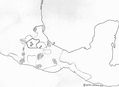
The map below shows generally what the Aztec empire looked like before it's fall. A map of the Aztec empire is a tricky thing to understand, because the nations of Central Mexico didn't have exact borders as countries often do today. Instead, the Aztec empire was more an alliance of city-states. Each of these cities had an area of influence and control. Also, the areas of Aztec influence differed in that some areas were areas of direct control, other areas involved city-states that paid tribute, and other areas were alliances of other types. Let's take a look at this map and then a brief explanation...
Note: You can find more maps of the Aztec empire here.
The Aztec map

This map of the Aztec Empire, again, shows general areas of influence. It's not meant to show exact locations and borders. First, you'll see a couple of pyramids and a large T. This represents the Aztec capitol, Tenochtitlán, now Mexico City, and the neighbouring Teotihuacán. This area, enclosed in the solid black line, was the Aztec heartland - the area that was directly and most solidly controlled by the emperor in Tenochtitlán. This is where the Aztec empire basically started, then moving out to the east, finally expanding west and south.
The larger outline shows the general area of influence of the Aztecs, but this influence differed. The majority of this area included cities and towns that had been conquered by the Mexica people (who controlled the empire). These were cities that paid tribute on a regular basis to the Aztec empire.
But you'll also see areas with diagonal lines. This represents general regions that were not necessarily required to pay tribute, but they did protect the empire from enemies.
The pyramid with the little t represents Tlaxcala, a city which the Aztec empire never totally conquered. The Aztec map shows other areas where enemy tribes lived. For example, the Aztecs had an ongoing fight with the Tarascans to the west of the empire. To the north of the Tarascans (also western) was Metztitlán. Areas like these were sometimes allied, sometimes at war.
The V on the coast represents Veracruz, originally named La Villa Rica de la Vera Cruz (the rich city of the true cross) by Hernan Cortes, who landed there to begin his conquest of Mexico.
More Aztec maps
You can find a simple interactive Aztec map, though it doesn't show areas of influence. Mexconnect has a map showing Aztec influence, as well as archaeological sites related to the Aztec empire. There is also an excellent map that can give you an idea of where the empire was related to modern day Mexico - Aztec Centers in the Valley of Mexico.
There's also a remarkable map of Tenochtitlán that you can own on our Aztec posters page. Just scroll down to the 9th poster.